


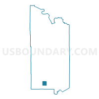
Culver Twp. Voting District, St. Louis County, Minnesota
About
Outline

Summary
| Unique Area Identifier | 604204 |
| Name | Culver Twp. Voting District |
| County | St. Louis County |
| State | Minnesota |
| Area (square miles) | 35.07 |
| Land Area (square miles) | 34.59 |
| Water Area (square miles) | 0.48 |
| % of Land Area | 98.64 |
| % of Water Area | 1.36 |
| Latitude of the Internal Point | 46.91014140 |
| Longtitude of the Internal Point | -92.59997730 |
Maps


Graphs
Select a template below for downloading or customizing gragh for Culver Twp. Voting District, St. Louis County, Minnesota


Neighbors
Neighoring Voting District (by Name) Neighboring Voting District on the Map
- Alborn Twp. Voting District, St. Louis County, MN
- Arrowhead Twp. Voting District, St. Louis County, MN
- Brevator Twp. Voting District, St. Louis County, MN
- Brookston Voting District, St. Louis County, MN
- Industrial Twp. Voting District, St. Louis County, MN
- Ness Twp. Voting District, St. Louis County, MN
- New Independence Twp. Voting District, St. Louis County, MN
- Stoney Brook Twp. Voting District, St. Louis County, MN
Top 10 Neighboring County Subdivision (by Population) Neighboring County Subdivision on the Map
- Brevator township, St. Louis County, MN (1,269)
- Industrial township, St. Louis County, MN (800)
- Alborn township, St. Louis County, MN (460)
- Stoney Brook township, St. Louis County, MN (332)
- New Independence township, St. Louis County, MN (299)
- Culver township, St. Louis County, MN (294)
- Arrowhead township, St. Louis County, MN (223)
- Brookston city, St. Louis County, MN (141)
- Ness township, St. Louis County, MN (62)